
- This event has passed.
Montecito Sunset Hike | San Ysidro Trail
Activity Navigation
Summary
This is an intermediate-level, conditioning-oriented hike, through and then above San Ysidro Canyon to the McMenemy Overlook, and typically continuing on to do one of three foothill loops above Montecito.
Description
Note: 4:00pm start...Please bring a headlamp or flashlight
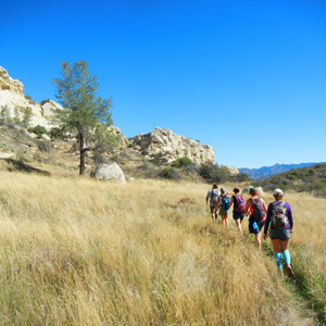
Please join us for our next Montecito Sunset Hike. The hike offers ample room to stretch your legs, elevation gain for fitness improvement, and terrific views up and down.
As explained below, hike options range from 3 miles and 650 feet of gain to 6 miles and 1400 feet of gain. The specific route we take will depend on the group, but since the trails are very well marked, you have the option of taking shorter routes back to the trailhead if you would like.
On all these routes, the terrain is either dirt fire road or well-tended single-track trail.
Please be sure to bring water, a snack, an extra layer of clothing, and a headlamp or flashlight.
Details of the hike are provided below…hope to see you there!
- Hike Type: Conditioning
- Level: Intermediate
- Route Type: Out & back, loop, or lollipop
- Distance: 3-6 miles
- Elevation gain/loss: 650-1400 feet
- Terrain: Footpath and dirt road
- Leashed dogs: Yes
Route summary:
This hike will take us 3-6 miles roundtrip, beginning in San Ysidro Canyon, turning on the McMenemy Trail until reaching the McMenemy Overlook, and normally continuing through the Montecito foothills on one of three loops, with impressive views of the coast and Pacific in any case.
Our route begins at the San Ysidro trailhead on Mountain Drive, proceeds north along the San Ysidro Trail, passes several homes, and follows a mix of single track trail and dirt road for about a half mile. At the half-mile mark, we turn west on the on the McMenemy Trail and follow it up for about a mile to the McMenemy Overlook.
When we reach the McMenemy Overlook, there are four route options:
> Out & back route – we can return back to our starting point by the same route. This out and back route is just under 3 miles roundtrip and provides approximately 650 feet of elevation gain and loss.
> San Ysidro Canyon loop – we can continue north on the Girard Trail for about three-quarters of a mile, descend east back into San Ysidro Canyon on the Edison Catway for about the same distance, and then turn north for a mile and return to the trailhead via San Ysidro Canyon. This loop route is about 4 miles roundtrip and offers approximately 1000 feet of elevation gain and loss.
> Saddle Rock loop – we can continue north on the Girard Trail for about three-quarters of a mile, turn west on the Edison Catway for about 0.3 miles, descend south on the Saddle Rock Trail to the McMenemy Trail, turn east on the McMenemy Trail for about three-quarters of a mile until we are back at the McMenemy Outlook, and then return to the trailhead via our initial route to the McMenemy Outlook. This lollipop route is about 5 miles roundtrip and offers approximately 1200 feet of elevation gain and loss.
> Cold Springs loop – we can continue north on the Girard Trail for about three-quarters of a mile, turn west on the Edison Catway for about a mile, descend south on the Cold Springs Trail to the McMenemy Trail, turn east on the McMenemy Trail for about a mile until we are back at the McMenemy Outlook, and then return to the trailhead via our initial route to the McMenemy Outlook. This lollipop route is about 6 miles roundtrip and offers approximately 1400 feet of elevation gain and loss.
Please note that San Ysidro Canyon and the trails listed above have some poison oak growing, though it is easily avoided in the sections of the trails we will be following on this hike. That said, you will need to walk attentively at some points on the trail and/or wear hiking pants, especially if you are highly allergic.
The initial section of our hike is partly shaded, but the route steadily gives way to open hillside and chaparral. Since we begin in a relatively sheltered area and reach exposed areas above the Pacific, weather conditions can range from cool to hot and calm to windy.
Whichever route we take, we will stop either at the McMenemy Overlook or an alternative spot to enjoy the great late-day or early-evening views of the Pacific, offshore islands, and surrounding coastal peaks. After our stop, we will return to our starting point as described above.
Sponsor
Santa Barbara County Trails Council
The person or organization running the activity appearing above is the source of the information. You should use your own judgment in deciding whether an activity is suitable for you. Nothing on this website should be considered advice and all content is provided for information purposes only. All inquiries about the activities advertised or promoted on this website should directed to the activity organizer, whose contact details appear in the activity details.
Healthy People Healthy Trails does not warrant that the person and/or organization running the activity has (1) obtained all relevant permits to do so; and (2) appropriate insurance cover, be it public liability or otherwise, in respect of the activity. Healthy People Healthy Trails accepts no liability for any injuries, death or damage to property occurring as a result of or related to any activities listed on this website.