
- This event has passed.
Santa Barbara Sunset Hike | Painted Cave
Activity Navigation
Summary
This is an intermediate-level, conditioning-oriented hike, out and back on Painted Cave Road, which goes as far as Camino Cielo Road.
Description
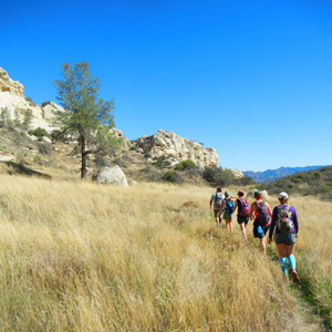
The hike offers ample room to stretch your legs, elevation gain for fitness improvement, and remarkable mountain and ocean views up and down.
The hike’s distance and elevation change will depend on how far you follow Painted Cave Road. The full roundtrip route is about six miles, with 1400 feet of gain/loss and a total hiking time of roughly 3 hours. Since our route is out and back, and along a single well-marked road, you can turn back earlier if you become winded or are short on time.
Please be sure to bring water, a snack, an extra layer of clothing, and a headlamp or flashlight.
Details of the hike are provided below…hope to see you there!
- Hike Type: Conditioning
- Level: Intermediate
- Route Type: Out & back
- Distance: ~6 miles
- Elevation gain/loss: ~1400 feet
- Terrain: Paved road
- Leashed dogs: Yes
Route summary:
This hike will take us up to 6 miles roundtrip, along the narrow and upwardly winding Painted Cave Road, with its impressive and extended views of Santa Barbara, Goleta, and the Pacific.
Our route begins at the parking area just off Highway 154 on San Marcos Road and, after we carefully cross Highway 154, proceeds along along Painted Cave Road for about three miles. The route passes some interesting sandstone formations and the Painted Cave area, and finally reaches Camino Cielo Road at roughly 2700 feet.
Overall, the route is steadily ascending, rather than steep, though there are a few moderately challenging sections. As we ascend, the route offers quite dramatic views of the Santa Ynez mountains, Santa Barbara and Goleta, and the Pacific and offshore islands to the south and west.
The initial section of our hike is somewhat sheltered, but the route quickly takes us to open hillsides, before returning to more shaded areas near the top. Since we pass through both relatively protected areas and more exposed ones above the Pacific, weather conditions can range from cool to hot and calm to windy.
We will continue to our turnaround point, stop briefly to rest, and then enjoy the great late-day or early-evening views as we return to our starting point by the same route.
Essentials:
Please wear – hiking or athletic pants or shorts, one or more wicking shirts appropriate to the temperature, comfortable hiking or running shoes, a hat and other needed sun protection, your favorite undergarments and accessories, and a light pack to hold your gear.
Please bring – at least 1 liter of water, on-trail snacks, extra layers of clothing in case you become cold, a charged cell phone, identification, a headlamp or flashlight, a waterproof shell if rain is forecast, and any medications or anything else you might need on the trail.
Parking:
Please parallel park in the dirt parking area alongside the south side of San Marcos Road, approximately 100 yards in from Highway 154. Carpooling is encouraged, both to lower our carbon footprint and to reduce the number of parking spaces we use. Please do not leave anything of value in your vehicle, at this or any parking area.
Directions:
Coming from the Santa Barbara area, take either the 101, Cathedral Oaks Road, or Foothill Drive (Highway 192) to Highway 154 and then drive north (toward the mountains or away from the ocean) to San Marcos Road. San Marcos Road is 5.5 miles on Highway 154 from the 101 and 4.8 miles from Cathedral Oaks and Foothill. When you reach San Marcos Road, turn left and look for the dirt parking area on the left.
Alternatively, from Goleta, you can take San Marcos Road from Cathedral Oaks Road and drive 3.6 miles north to the dirt parking area, which will be on the right, just before reaching Highway 154.
From the Santa Ynez Valley, take Highway 154 to San Marcos Road. When you reach San Marcos Road, turn right and look for the dirt parking area on the left.
Owing to its rural nature, there is no public transportation to this meetup location.
Sponsor
Santa Barbara County Trails Council
The person or organization running the activity appearing above is the source of the information. You should use your own judgment in deciding whether an activity is suitable for you. Nothing on this website should be considered advice and all content is provided for information purposes only. All inquiries about the activities advertised or promoted on this website should directed to the activity organizer, whose contact details appear in the activity details.
Healthy People Healthy Trails does not warrant that the person and/or organization running the activity has (1) obtained all relevant permits to do so; and (2) appropriate insurance cover, be it public liability or otherwise, in respect of the activity. Healthy People Healthy Trails accepts no liability for any injuries, death or damage to property occurring as a result of or related to any activities listed on this website.