
- This event has passed.
National ParkRx Day: Rattlesnake Canyon To La Cumbre Peak
Activity Navigation
Summary
As part of the Santa Barbara County Trails Council and Santa Barbara County Hiker’s participation in National ParkRx Day, please join us for our next Rattlesnake Canyon to La Cumbre Peak hike.
Description
More about National ParkRx Day: https://healthypeoplehealthytrails.org/docs/National-ParkRx-Day-save-the-date.pdf
This is a two-section, two-level, out and back hike. The first section is an intermediate-level hike through Rattlesnake Canyon. This section covers about 4 miles roundtrip, has roughly 500 feet of elevation gain, and proceeds as far as the turn onto the Tunnel Trail Connector.
The second section of the trail is more advanced. It ascends from the Rattlesnake Canyon floor on the Tunnel Trail Connector at a fairly steep grade, proceeds along the Tunnel Trail Connector and then onto the upper part of the Tunnel Trail, continues up to the Tunnel Trail’s crest at East Camino Cielo, and lastly climbs along East Camino Cielo to the lofty vistas of 4000-foot La Cumbre Peak, high above Santa Barbara and the surrounding wilderness. This second section adds about 10 miles roundtrip and 3000 feet of elevation gain to the totals of the first section.
Overall, this is an adventure meetup for physically-fit people hiking at an intermediate level and above, and who enjoy time outdoors with fun and friendly people sharing similar interests and fitness goals. Since our route is out and back, and well-marked, you can and should feel free to turn around and return to our starting point whenever you would like.
The hike’s distance and elevation change will depend on how far you follow the trail. If you hike with us all the way to La Cumbre Peak, expect a roundtrip of about fourteen miles, 3500 feet of gain/loss, and a total hiking time of about seven hours.
If you are planning to do the full hike, please be sure to bring at least 3 liters of water, on-trail snacks, a top-of the trail lunch, a sun hat, and extra layers of clothing. For the first section only, about 1 liter of water, some on-trail snacks, a sun hat, and one extra layer of clothing should suffice.
Details of the hike are provided below…hope to see you there!
RATTLESNAKE CANYON TO LA CUMBRE PEAK HIKE
- Hike Type: Adventure
- Level: Intermediate-Advanced
- Route Type: Out & back
- Distance: Up to ~14 miles
- Elevation gain/loss: Up to ~3500 feet
- Terrain: Mostly footpath, some fire road
- Leashed dogs: Yes
ROUTE SUMMARY:
This hike will take us up to 14 miles roundtrip through and then above Rattlesnake Canyon in Santa Barbara, on a progressively athletic and quite scenic route spanning the Rattlesnake Canyon Trail, Tunnel Trail Connector, Upper Tunnel Trail, and East Camino Cielo roadway. In general, we will walk in a north-westerly direction on our way in, and a south-easterly one on our way out.
The route initially offers a great coastal canyon experience, with riparian forest and meadow, as we make our way through Rattlesnake Canyon to the turn onto the Tunnel Trail Connector. After the turn, the trail becomes much steeper, providing steadily increasing and then panoramic views of the Santa Ynez range, Santa Barbara, and the Pacific and offshore islands.
The full route is great training for more advanced area hikes, including the Franklin Trail, the crest and peak hikes above Ojai, and the Wilson and Baldy ascents in the San Gabriel Mountains.
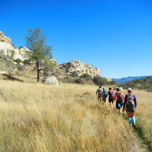
Our route begins at the Rattlesnake Canyon trailhead, which is located by the stone bridge on Las Canoas Road in Santa Barbara (directions below). We initially move northward through the canyon, passing a mix of open meadows and more heavily forested areas. Most of this portion of the trail is a wide single track, and is often quite picturesque as it winds through Rattlesnake Canyon.
At the upper end of the initial canyon section of the hike, and at about the two-mile mark and after roughly 500 feet of elevation gain, we reach eastern end of the Tunnel Trail Connector. We will stop there to rest for a short time, before continuing onto the Tunnel Trail Connector and the second section of the hike.
Please note that this first section of the trail has some poison oak growing, though it is generally avoidable if you take care to step around it. Given this, you will need to walk attentively at some points on this part of the trail and/or wear hiking pants, especially if you are highly allergic. It is also worth pointing out that we will pass a few side trails along this portion of the route – but none that we will take either during our ascent or descent. Overall, this first part of the trail is scenic, well-traveled, and suited to people hiking at an intermediate-level.
After our first rest stop and as we proceed onto the Tunnel Trail Connector, the trail changes markedly in character. Our route becomes much steeper and more exposed to the sun and wind, as we ascend above the riparian woodland of the canyon and make our way to the chaparral and steep hillsides of the remaining portions of our route. This second section and upper part of the trail is suitable for people hiking at or near an advanced level.
As we proceed along the second section of our route, which extends roughly an additional five miles and 3000 feet of elevation gain, reaches East Camino Cielo, and then crests at La Cumbre Peak, we will have a steady, nearly uninterrupted ascent, with much of the trail in full sun. This section of the trail is single track until we reach rolling East Camino Cielo road, and includes a mix of moderate to steep switchbacks, along with steadily ascending hillside and ridge trail.
When we reach East Camino Cielo, we will stop briefly to gather the group. We will them walk west along the road for about 1.4 miles until we reach La Cumbre Peak, which is accessed at the end via a fairly sharp left turn that you will need to look for. At La Cumbre Peak, we will stop for an extended time to rest, enjoy the views, and have a top-of-the-trail lunch. After our rest stop, we will return to our starting point on Las Canoas Road by the same route as our ascent.
As summarized above, the initial section of our hike is within the canyon and partly shaded, but the route steadily gives way to open hillside and chaparral. Since we begin in a relatively sheltered area and reach exposed areas above the Pacific, weather conditions can range from cool to hot and calm to windy.
ESSENTIALS:
Please wear – hiking or athletic pants or shorts, one or more wicking shirts appropriate to the temperature, comfortable hiking or running shoes, a hat and other needed sun protection, your favorite undergarments and accessories, and a light pack to hold your gear.
Please bring – at least 3 liters of water, trail snacks and a top-of-the-trail lunch, extra layers of clothing in case you become cold, a charged cell phone, identification, a headlamp, a waterproof shell if rain is forecast, and any medications or anything else you might need on the trail.
PARKING:
Please park to the side of Las Canoas Road near the trailhead, and please be considerate of the residents in this quiet neighborhood area.
Carpooling is encouraged, both to lower our carbon footprint and to reduce the number of parking spaces we use at the trailhead.
Please do not leave anything of value in your vehicle, at this or any trailhead.
DIRECTIONS:
By car, take your favorite way to the corner of Mission Canyon Road and Foothill Drive (Highway 192), such as heading north from the Mission Street exit off the 101. Where Mission Canyon Road meets Foothill Drive, coming from the city, drive east for 1/4 mile on Foothill until you reach the Mission Canyon Road extension.
Once you reach the Mission Canyon Road extension on Foothill, head north for about 1/2 mile (do not turn left onto Tunnel Road) and take the very sharp right onto Las Canoas. Drive east for about a mile on Las Canoas, and then park at the trailhead. If you come to the Botanical Gardens, you have missed the sharp right onto Las Canoas.
For people interested in using public transportation to reach the trailhead, unfortunately the old Saturday shuttle to and from the Botanical Gardens is no longer running. While you can take the MDT #30 bus to the Santa Barbara Mission (or get near the Mission via the #3, #6 or #11 buses) and walk the remaining two miles to the trailhead, in general the roads near the trailhead are not pedestrian-friendly. I would therefore recommend that you arrange a ride or ride-share, or carpool with another person attending the hike, whether from the Mission or another location.
Sponsor
Santa Barbara County Trails Council
The person or organization running the activity appearing above is the source of the information. You should use your own judgment in deciding whether an activity is suitable for you. Nothing on this website should be considered advice and all content is provided for information purposes only. All inquiries about the activities advertised or promoted on this website should directed to the activity organizer, whose contact details appear in the activity details.
Healthy People Healthy Trails does not warrant that the person and/or organization running the activity has (1) obtained all relevant permits to do so; and (2) appropriate insurance cover, be it public liability or otherwise, in respect of the activity. Healthy People Healthy Trails accepts no liability for any injuries, death or damage to property occurring as a result of or related to any activities listed on this website.